
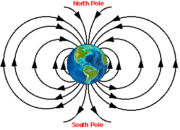
To a first approximation, the
Earth's magnetic field resembles that of an enormous bar magnet.
The field lines emerge from the southern half of the earth and
re-enter in the northern half. Several features of the Earth's
field vary in a predictable way across the surface of the globe
and might, in principle, be used in assessing geographic position.
For example, at each location on the Earth, the field lines intersect
the Earth's surface at a specific angle of inclination. On the
diagram above, note that near the equator, the field lines are
approximately parallel to the Earth's surface; the inclination
angle in this region is said to be 0 degrees. As one travels north
from the equator, however, the field lines become progressively
steeper. At the magnetic pole, the field lines are directed almost
straight down into the Earth and the inclination is said to be
90 degrees. Thus, inclination angle varies with latitude. As a
consequence, an animal that has the ability to distinguish between
magnetic inclination angles has a mechanism that it might be able
to use to approximate its latitude. A
second geomagnetic parameter that varies across the surface of
the Earth is the strength or intensity of the field. Although
intensity varies somewhat less predictably than inclination, the
general trend is that the field is strongest near the magnetic
poles and is weakest near the equator.
Some animals appear to use the small geographic differences in the Earth's magentic field to estimate their position. Because this information provides an estimate of location it is sometimes referred to as a magnetic map. This hypothesis is the subject of much debate and study among scientists who study animal navigation.