
|
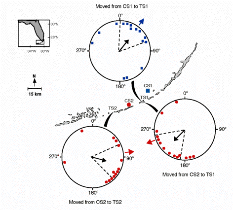
Lobsters were transported by boat from two capture sites (CS1, CS2) via circuitous routes to one of two test sites (TS1, TS2). In the orientation diagrams, each small symbol represents the mean angle of orientatin of a single lobster walking in the orientation arena. Blue squares indicate lobsters captured at CS1, whereas red circles indicate lobsters captured at CS2. In all orientation diagrams, the dashed lines represent the 95% confidence interval for the mean angle. Data are plotted relative to magnetic north. The blue or red arrow outside each orientation diagram indicates the direction from the test site to the capture site. In each case, the mean angle of orientation (black inner arrow) coincided closely with the direction toward the capture site and the 95% confidence interval encompassed this 'homeward' direction. |
 |
|
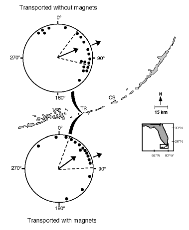
Orientation of lobsters transported overland by truck in distorted magnetic fields. All lobsters in this experiment were collected from a single capture site (CS) near Long Key and transported to the test site (TS) at Pigeon Key. One group of lobsters (upper diagram) was subjected only to the magnetic field distortions produced by the metal body of the truck. The second group (lower diagram) was subjected to stronger, additional field distortions caused by stationary and moving magnets. The arrows outside each orientation diagram indicate the direction from the test site to the capture site. The two distributions were not significantly different;instead, both groups of lobsters oriented approximately toward the capture site (71°).
|
 |